


WB Rain Forecast Until February 28: Heavy Showers in Multiple Areas, Storms with Hail Expected, Alert Issued
West Bengal is set to experience widespread rainfall along with thunderstorms and hail in several districts. Read on to know which areas are affected, the severity of the weather, and the official warnings issued.

WB Rain Forecast Until February 28: Heavy Showers in Multiple Areas, Storms with Hail Expected, Alert Issued
Introduction: Unstable Weather Patterns in West Bengal
- West Bengal is witnessing unstable weather as heavy rain, thunderstorms, and hailstorms are predicted for multiple districts.
- Meteorologists have warned of significant weather disturbances due to a low-pressure system in the region.
- The rainfall is expected to persist until February 28, affecting both rural and urban areas.
- The government has issued an alert, urging people to take precautions and stay updated on weather reports.
What is Causing the Rain and Storms?
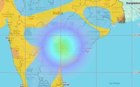
- A low-pressure system over the Bay of Bengal is drawing moisture into the atmosphere, leading to rain formation.
- Western disturbances and cyclonic activities are influencing the temperature drop, increasing instability.
- The combination of these factors is resulting in thunderstorms, strong winds, and even hailstorms in some places.
- Weather experts suggest that such conditions are common during seasonal transitions but must be closely monitored.
Which Areas Will Be Affected?
- According to meteorological reports, rainfall will be widespread, covering several districts.
- Kolkata, Howrah, and Hooghly are expected to receive moderate to heavy rainfall.
- Nadia, Murshidabad, and Birbhum may experience thunderstorms along with strong winds.
- Purulia, Bankura, and Jhargram could see isolated hailstorms as cold and warm air masses collide.
- Coastal regions like Digha and Mandarmani might witness heavy showers and rough sea conditions.
Intensity and Duration of the Rainfall
- Rainfall is expected to continue intermittently throughout the weekend and into early next week.
- Light to moderate showers will begin today, gradually increasing in intensity.
- On Sunday, the likelihood of thunderstorms and hailstorms will be higher, particularly in northern and western districts.
- By February 28, weather conditions are expected to stabilize, with rain gradually decreasing.
Hailstorm Warning: What to Expect?
- Several regions have been put on alert for potential hailstorms, which could impact agricultural activities.
- Farmers are advised to take necessary precautions to protect standing crops from damage.
- Vehicles and outdoor structures may also be at risk of hail damage in areas experiencing strong storms.
- People are recommended to stay indoors and avoid open fields during intense weather activity.
Safety Advisory for Residents
- Avoid Unnecessary Travel: Heavy rain can cause waterlogging and slippery roads, increasing accident risks.
- Stay Indoors During Storms: Lightning and strong winds can pose dangers to people outside.
- Protect Electrical Appliances: Unplug sensitive devices to prevent damage from sudden power surges.
- Secure Loose Items: Strong winds can displace objects, so secure outdoor furniture and other belongings.
- Keep Emergency Contacts Handy: Be prepared for any disruptions by keeping essential numbers accessible.
Impact on Daily Life
- Transport: Flights, trains, and road transport may face disruptions due to rain-induced visibility issues.
- Markets and Shops: Businesses might experience lower footfall due to unfavorable weather conditions.
- Schools and Offices: Educational institutions may adjust schedules depending on the severity of the weather.
- Power Supply: Strong winds can lead to power outages in certain areas; residents should stay prepared.
Government and Meteorological Department’s Response
- The weather department has issued advisories to the public and state authorities regarding potential risks.
- Disaster management teams are on standby to address any emergencies arising from heavy rainfall or storms.
- Alerts have been sent to farmers, encouraging protective measures to minimize crop losses.
- Coastal areas have been advised to monitor sea conditions and follow safety guidelines.
How Farmers Can Protect Their Crops
- Covering crops with protective sheets can help minimize damage from hail.
- Draining excess water from fields can prevent flooding and root rot.
- Harvesting mature crops early may reduce the risk of complete losses due to extreme weather.
- Keeping irrigation channels clear can help manage water levels more effectively.
Precautions for People in Affected Areas
- Check local news and weather updates regularly for real-time information.
- Keep torches, power banks, and emergency kits ready in case of power failures.
- If driving, ensure that windshield wipers and vehicle brakes are functioning properly.
- Avoid taking shelter under trees or open structures during thunderstorms.
Will the Weather Improve After February 28?
- Meteorologists predict that weather conditions will start improving gradually from February 28 onward.
- The intensity of rainfall is expected to reduce, allowing life to return to normal.
- However, some districts may continue to experience light showers for a few more days.
- Temperature fluctuations may occur as the winter-to-spring transition takes place.
Conclusion: Stay Safe and Stay Informed
- The current weather conditions in West Bengal are expected to bring heavy rain, storms, and hail in multiple areas.
- Authorities have issued alerts and advised the public to take necessary precautions.
- Farmers, travelers, and residents must stay updated on official forecasts and follow safety measures.
- As the weather gradually stabilizes after February 28, it is crucial to remain cautious and prepared for any last-minute changes.
By staying informed and following safety guidelines, everyone can effectively navigate the upcoming days of unpredictable weather.
What's Your Reaction?